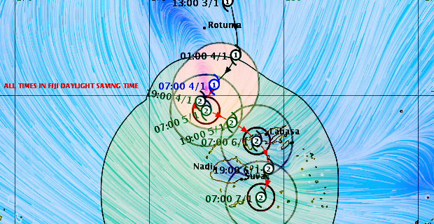
The whole of Fiji should now prepare for Tropical Cyclone Mona based on its erratic movement as there is a possibility that it could it could track towards Vanua Levu or Viti Levu.
This is based on the current projections.
Nadi Weather Office Senior Forecaster Amit Singh says looking at the uncertainty of the track of Cyclone Mona, the whole of Fiji should be prepared for a Category Two cyclone.
Singh says based on the projections, the centre of Cyclone Mona could make landfall in Vanua Levu tomorrow night into Sunday morning.
He adds that based on the uncertainty of the track, some of the guidance are showing that Cyclone Mona could track further south and the center could pass close to Viti Levu or even over Viti Levu.
These are the two scenarios so far.
TC Mona Threat Track Map as at 8:51am 4th January [Photo: met.gov.fj]
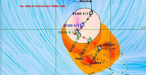
Tropical Cyclone Mona which is currently a Category Two cyclone is located about 240km north of Yasawa and about 360km north of Nadi.
Cyclone Mona is moving south south-west at about 20km/h.
Close to the center, the cyclone has average winds of about 85km per hour with momentary gusts to 120km per hour.
Singh says this cyclone has tracked south south-west in the last 12 hours, a bit away from Fiji, however Cyclone Mona is expected to make a clockwise loop and start to move east south-east towards the Fiji Group from tonight into early tomorrow.
Singh says Cyclone Mona is expected to enter Fiji waters around midday tomorrow as a Category Two Cyclone and track east south east.
Singh has stressed again that flooding of major rivers is still a big concern as heavy rain will be experienced throughout the country.
He says gale force winds extend to about 200km from the Center of the cyclone.
A gale warning has been issued for Yasawa and Mamanuca Group while a Tropical Cyclone alert is in force for the rest of Fiji.
A heavy rain warning remains in force for Yasawa and Mamanuca Group, Vanua Levu, Taveuni and nearby smaller islands, Lau and Lomaiviti Group the eastern half of Viti Levu which includes the Central Division.
A heavy rain alert is now in force for the rest of Fiji.
The Nadi Weather Office says with soil already saturated and more rain predicted, the chances of flooding of low lying and flood prone areas is high.
Sea flooding of low‑lying coastal areas and damaging heavy swells is also anticipated.
Coastlines are at high risk of heavy swells and storm surge.
All communities living in low coastal, flood prone and low lying areas are reminded to take all necessary precautions, similarly for those living in landslide prone and low lying coastal areas to remain vigilant.