Tropical Cyclone Winston has been upgraded to a Category 5 system which means that it has average winds of upto 205 kilometres per hour to 285 kilometres per hour.
Winston continues to move towards Fiji.
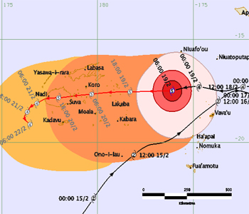
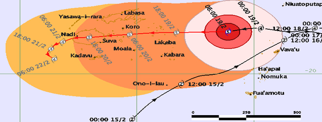
The Nadi Weather Office says the eye of the cyclone is currently located 300 kilometres East North East of Lakeba.
It is expected to enter the Fiji waters early tomorrow morning and is expected to be just near Lakeba at about 6am tomorrow.
Winston will then move past to Koro and then onwards to Viti Levu.
The eye of the cyclone is now forecast to make landfall north of Nausori near Korovou.
Tropical Cyclone is expected to move across Viti Levu before exiting near Nadi. This is expected to occur at about 6pm tomorrow night.
Na Draki says this system poses a direct and very serious threat to Fiji.
Heavy rain, dangerous storm surges and very destructive storm to hurricane force winds are forecast to affect Fiji.
Destructive winds will be experienced in Lau tomorrow morning as there is a hurricane warning for the group.
In the past few hours the cyclone has increased its forward speed, and hence times of arrival previously predicted are no longer valid.
Currently the cyclone is moving westwards at around 20 kilometres per hour towards Fiji.
On the current forecast track the eye of TC Winston will enter the Fiji waters at about 6am tomorrow and pass between Lakeba and Vanuabalavu tomorrow during the latter part of the morning.
At this time best indications are that the centre of the cyclone will make landfall north of Nausori close to Korovou and Natovi between midnight and 3am on Sunday morning.
For the north and west, showers increasing and tending to rain tomorrow with heavy falls developing.
Expect strong winds in the North and West from tomorrow.
Damaging to destructive winds may begin several hours before the cyclone centre passes overhead or nearby.
It is likely to still be a category 3 cyclone as it exits Viti Levu close to Nadi early late Sunday morning.
Please secure your homes and ensure that there are no weak structures around.
During cyclones, there are water and power cuts.
You are advised to store water, stock up canned food and also get a transistor radio and batteries to listen to the weather updates.
We will bring you continuous weather updates.
Stay with us.
Earth Wind Map: