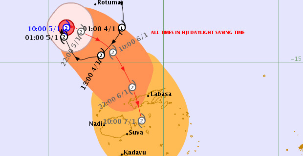
Tropical Cyclone Mona which has now been downgraded to a Category One Tropical Cyclone is currently moving Eastwards and should start tracking Southeast towards Fiji in the next 9-12 hours.
Nadi Weather Office Senior Forecaster, Amit Singh has confirmed that Category One Tropical Cyclone Mona was located about 380km North-Northwest of Yasawa-i-rara or about 460km Northwest of Labasa at 1 this afternoon.
He says that Cyclone Mona is moving East-Northeast at about 10km/hr.
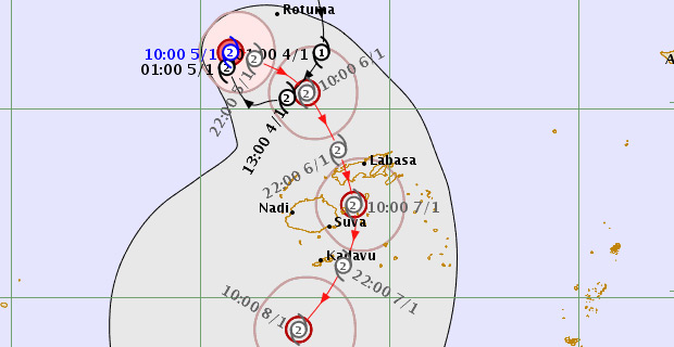
TC Mona Forecast Track Map as at 2:40pm 5 Jan 2019 [Photo: met.gov.fj]
Category One Tropical Cyclone Mona has winds of about 75km/hr with momentary gusts of about 100km/hr close to the centre.
Damaging gale force winds are likely to begin several hours before the cyclone centre passes overhead or nearby.
Singh says based on the projections the centre of Cyclone Mona could make landfall in Vanua Levu late tomorrow afternoon into tomorrow night.
He adds that based on the uncertainty of the track, some of the guidance is showing that Cyclone Mona could track further south and the center could pass close to the east of Viti levu.
He says that there is a low chance for the centre to pass over Viti Levu.
These are the scenarios in the movement of Tropical Cyclone Mona.
On the forecast track the centre is expected to be located about 330km North of Yasawa-i-rara or about 390km Northwest of Labasa at 1am tomorrow morning.
A gale warning remains in force for Yasawa and Mamanuca groups and Western half of Vanua Levu.
A tropical cyclone alert remains in force for the rest of Fiji.
A strong wind warning remains in force for all land areas and waters of Fiji.
A heavy rain warning remains in force for the whole of the Fiji group.
A flood warning remains in force for all low lying areas, small streams and areas adjacent to major rivers of Fiji.