A heavy rain warning remains in force for the whole of Fiji.
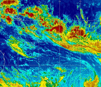
Nadi Weather Office Director, Ravin Kumar says the Tropical Disturbance was located 430 kilometres North North West of Nadi earlier today.
The active rain bands will start affecting the Fiji group from tonight and the disturbance is expected to become a Tropical Depression tonight or early tomorrow morning.
The system is continuing to move towards the Fiji group.
The Weather Office says there is still a moderate 20 to 50% chance of the system developing into a tropical cyclone over Fiji waters.
Over the next 24 to 48 hours we expect the Tropical Disturbance to slowly intensify. Its movement is very slow.
Heavy rain and flooding will be the major concern for now.
Localised flash flooding is likely with the heavy rain tonight and tomorrow, while a more significant risk in the medium term towards the latter part of the week will be more widespread river flooding, especially about the west and the north.The rain and isolated thunderstorms are forecast to become more frequent and heavier tomorrow, Friday and into Saturday.
Na Draki says by tonight it is likely that a strong depression will lie close to Fiji with the moderate possibility of a tropical cyclone by Friday or Saturday close to Fiji. Current forecasts indicate this system will move over Fiji from the northwest and move east-southeast across the Yasawas, Bligh Waters passing between Viti Levu and Vanua Levu then into the Lomaiviti region.
Rain is likely to be the main hazard with this system.
A strong wind warning also remains in place for the whole of the Fiji group.
Stay with us for updates.