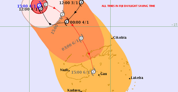
Category Two Tropical Cyclone Mona is in the process of making the clockwise loop as forecasted and is expected to start tracking towards the Fiji group in the next 3-6 hours.
The whole of Fiji should now prepare for Tropical Cyclone Mona based on its erratic movement as there is a possibility that it could it could track towards Vanua Levu or Viti Levu.
This is based on the current projections.
Nadi Weather Office Senior Forecaster Amit Singh says based on the projections and the 6 hours delay the centre of Cyclone Mona could make landfall in Vanua Levu tomorrow afternoon into tomorrow night.
He adds that based on the uncertainty of the track, some of the guidance is showing that Cyclone Mona could track further south and the center could pass close to Viti Levu or even over Viti Levu.
These two scenarios still remain despite the delay in the movement of Tropical Cyclone Mona.
Category Two Tropical Cyclone Mona was located at 400km north‑northwest of Yasawa i Rara or about 510km northwest of Labasa at 4am today.
The cyclone is moving north northwest at about 13-15km/hr.
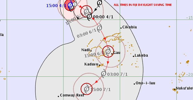
TCMona Forecast Track Map as at 5:12am 5 Jan 2019 [Photo: met.gov.fj]
Close to the center, the cyclone has average winds of about 95km per hour with momentary gusts to 130km per hour.
Singh says the centre of the cyclone is expected to close to Vanua Levu from midmorning tomorrow into tomorrow afternoon. On the forecast track, the centre is expected to be located about 300km north‑northwest of Yasawa‑i‑Rara or about 380km northwest of Nadi at 1pm today.
Gale force winds extend to about 200km from the center of the cyclone.
The outer active rain bands from Tropical Cyclone Mona have started affecting the northern and eastern parts of the country.
As the system moves closer to Fiji, rain will become heavy and frequent.
Depending on the closeness of the system to pass land areas, gale force winds can be expected especially over the Yasawa and Mamanuca Group, Vanua Levu, Taveuni and nearby smaller islands.
Damaging winds are likely to begin several hours before the cyclone centre passes overhead or nearby.
The effects of wind can cause damages to well built framed homes which can blow away roofs, trees uprooted and branches being broken, severely damage weak structures, totally destroy shallow rooted crops, cause loose objects to fly, damage electricity lines and poles and damage water infrastructure.
A Gale warning is now in force for Yasawa and Mamanuca Group and the Western half of Vanua Levu and a Tropical Cyclone alert remains in force for the rest of Fiji.
A strong wind warning remains in force for all land areas of Fiji.
A heavy rain warning remains in force Fiji.
A flood warning remains in force for all low lying areas, small streams and areas adjacent to major rivers of Vanua Levu.